
In the post I wrote last week comparing the Grand and Central West End MetroLink stations, I concluded with a question: “Would additional stations or even a different alignment have better served the neighborhoods MetroLink passes?”
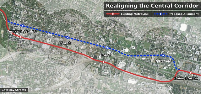
As the map above shows, I believe that a MetroLink alignment along Market St and Forest Park Ave would more effectively served the city’s central corridor, the city’s spine, than the existing alignment. The wide right-of-ways and long intersection spacings of both Forest Park Ave and Market St could easily accommodate MetroLink at-grade without significantly slowing the line’s speed down. In a way, it’s a shame St. Louis didn’t have any money of it’s own to invest in bettering MetroLink’s route when it was built. But, then again, who can resist free [right-of-way]?
Glancing at the stations along this relocated transit line, a new “infill” station at Jefferson would bring convenient MetroLink service to the corporate campus for Wells Fargo Advisors and other area businesses. Adding a station at Jefferson on the existing alignment would be of limited value given the area’s isolation similar to the existing Grand station.
Speaking of Grand, relocating the station north to Forest Park Ave would bring MetroLink 1/4-mile closer and within very easy walking distance to SLU making MetroLink a significantly more attractive option to the university’s students and faculty. The entire main campus, in fact, would be within a 1/2-mile radius of the station as would be parts of Grand Center. Additionally, bringing the station out of the valley is much more likely to encourage transit oriented development than the existing station site.
Splitting the difference between the Grand and Central West End stations is a station at Sarah. This station would serve the growing CORTEX district as well as the small neighborhood commercial strip to the north.
Interestingly, there have been multiple proposals for a MetroLink station at or in the vicinity of Sarah St in the past. Back in 1997, when debates centered on whether the Cross County Extension should be routed north or south of Forest Park, the south-of-the-park route would have included a station at Boyle Ave before diverging from the main line. More recently, the 2003 Midtown Strategic Development Plan proposed a station at Sarah to serve the then called Technopolis business park.
Technopolis is located between two MetroLink stations – one at Euclid Ave. and one at Grand Blvd. – that are approximately 1.5 miles apart. The Midtown Plan recommends adding a new station at Sarah St., midway between the existing two stations, to directly serve Technopolis. A new, conveniently located station should add to the area’s attractiveness to new businesses and employees. Also, this station, especially if developed with a park and ride facility, could add to the attractiveness as of Midtown as a residential area with easy access to downtown and other employment centers served by MetroLink.
Lastly, there are pros and cons to relocating the Central West End station to Forest Park Ave. On the up side, the station would be closer to the residential and commercial neighborhood that gives the station it’s name; on the down side, the station would be on the periphery of the BJC hospital complex instead of at its heart. Also, the station would no longer be within walking distance of the Forest Park Southeast neighborhood to the south. Given the increasing density of the neighborhood north of Forest Park Ave, however, the down sides of moving the station out of the hospital campus might not be as great as they seem.
Interstate 64 is often called St. Louis’s spine as it runs the length of the region’s favored quarter from downtown to Chesterfield. While this may be true west of Clayton, east of the innerbelt, it is not I-64 that serves as St. Louis’s spine, but rather a combination of Forest Park Ave/Market St or Lindell Blvd/Olive St. Those are the streets on which the city lives and breathes, not the highway. For that reason, it would make sense that MetroLink’s spine aligned with the city’s. The result would be greater intracity connectivity and an additional transportation option connecting the places we already go.
![]() Cross-posted at nextSTL.
Cross-posted at nextSTL.
Love the idea (and commented such on your last post). Just want to point out a few concerns.In theory, the Scott Ave maintenance yard could remain with a non-revenue track between it and Union Station. However, building a wye or track split beside the Drury Inn (or now another hotel?; haven't lived there in 4 years) appears to be challenged in constructability, due to a super-elevated curve for the existing tracks.I'm also concerned about wasting the newly replaced Vandeventer bridge, plus moving the potential Sarah station farther from the Grove.To address the two concerns listed above, I'd recommend a hybrid alignment, where you would only shift to Forest Park Avenue between Vandeventer and Union Station. Indeed, there is an existing RR spur just west of the Vandeventer bridge. That way, you keep the new Vandeventer bridge as non-revenue spur to the Scott VMF, but you locate the Sarah station more centrally between The Grove and Cortex.
I'd also add (same poster) that only using Forest Park Avenue between roughly Spring and Compton could utilize the "free" right-of-way of the inside lanes that actually go under Grand for a grade-separated station there. St. Louis MetroLink is one of only three fairly exclusive LRT systems in the US (Newark and Charlotte are the others) with very limited crossing of streets and using crossing gates. Other LRT systems (Denver, Portland, Dallas, etc.) use semi-exclusive treatments without gates at intersections. Given the St. Louis paradigm, using Forest Park Avenue in only this section would provide a fairly exclusive R/W, unlike the boulevard section of Forest Park Avenue between Spring and Euclid, which shouldn't be ruined by (and likely to wide of intersections for) crossing gates.
I do like using Market St between Union Station and Compton. Market appears wide enough to carve out an exclusive median for MetroLink. A parallel route may be Clark Avenue or 40/64, but that would place stations farther from Wells Fargo and Harris-Stowe.Speaking of stations, I think Jefferson should be moved to Ewing to serve both employment and the college. However, if there would be interest in developing dense development on all those parking lots about Market/Jefferson, then maybe build a Jefferson station (in addition to a Compton one for HSSU).As for how you get between Union Station and Market St, your current alignment comes too close to the FBI for GSA comfort. I remember Northside-Southside having problems with 10th & Clark about the Eagleton Courthouse. Instead, I'd cut MetroLink through all those parking lots with joint development above an offline Jefferson station. A joint development may also help pay for new below-grade cuts of Jefferson and Market for MetroLink to emerge in the median of Market just west of Beaumont St.
The alignment you propose highlights one of the worst kinks in our system.I'd like to see a plan for a new continuous Clark Avenue between Grand and the Arch Grounds (yeah, punch it through the Union Station parking lot right under the canopy). The FPP-Market intersection is horrible. It's a stack of ramps and overpasses that eats up developable real estate, terminates two important roads that should go seamlessly into each other, and messes up Harris-Stowe's front door.I'd like to see a simple compton overpass at 64 with an orthagonal Clark Ave north of it and a FPP/A-Market boulevard parallel to that. That'd free up lots of land for development and put two full blocks between FPP-Market and the interstate. If all the new publically-owned parcels were deeded to the public Harris-Stowe State University, they could sell off the land west of Compton and build on the eastern side. It'd be a new day in Midtown.
How did you create this map.
Anon #1/#2 – Since I'm proposing ~3 miles of new alignment and an optimistic likelihood of this happening is far off in the future, I don't think redoing a few curves nor the Vandeventer bridge is that big of a deal. And like yourself, I do like the mini-metro nature of MetroLink, but I don't think 6 intersections in over 1.5 miles is that big of a deal. Ideally, I'd like to see most of this alignment in a subway, but that might be asking for a bit much.Anon #3 – I agree a station at Ewing would be closer to Harris Stowe, but I wonder whether a station at Jefferson would integrate with buses better. The university is still, at least, within 1/2 mile of the station.Anon #5 – I used Inkscape to create the map. With the program, I simply imported an aerial of St. Louis, then drew lines on top.
As a graduate student at SLU and soon-to-be Grand Center worker, I agree that the Grand stop needs to be changed. It is AWFUL. After climbing lots of stairs you come up to the middle of a bridge and a busy street that are not close to anything and not pedestrian friendly. Cars are also stopping on the bridge, in traffic, to pick up or drop off passengers. Grand Center is a thriving arts district with 1.3 million visitors per year and would greatly benefit from a metro stop for people attending shows. SLU would also benefit. Students have been hit by cars, mugged. A closer stop would benefit Metro, SLU, all the arts institutions of Grand Center, and the City.
this is why metrolink needs a third and mabey a fourth line added to the system like the green line and the yellow line and keep the trains running all night
I think your idea is impractical and would be a poor use of funds. The opposition would be overwhelming, with perhaps a 10-15% approval rate. I would like to see whatever meager funds that are available spent on one of the extensions already proposed, such as extending the Red Line into St. Charles County. However, I realize there is so much opposition in that area to the plan that it isn’t especially practical, either. The Blue Line currently ends sort of in the middle of nowhere in Shrewsbury. I would like to see it extended further but am not sure how much interest there is in that area for this kind of public service.
St. Louisans have a great light rail system, but most seem to have no interest. I think travel by car is relatively easy and cheap for many or most in the area. I see mostly minorities utiilizing the system, as well as a few progressively minded individuals like myself who like it or think it is something worth supporting. It is similar to the situation in Milwaukee where I used to live, except there is no light rail system there, mostly due to opposition by conservatives. As St. Louis and Missouri are even more conservative, I would count your blessings. Some number of other cities haven’t done nearly as well.